June 2014 was an average month with no record-breaking weather. The month was warmer and drier than average with very light winds.
The maximum temperature for the month was 23.6°C, the highest of 2014 so far, recorded on the 23rd at 16:04, and the minimum temperature was 6.0°C on the 6th at 04:54. The monthly average was 14.8°C, 0.8°C higher than normal, with the average high being 19.2°C and the average low 10.5°C. The average dew-point was 11.4°C and the maximum heat index was 25.2°C at 19:25 on the 20th. There were 105.7 sunshine hours in the month, slightly lower than 2013’s total of 107.9 hours.
There were 39.8 millimetres of rainfall in the month, lower than the average of 61.4 millimetres. The wettest day was the 2nd when 9.6 millimetres of rain fell. No rain at all was recorded from the 15th until the 26th. Rainfall for 2014 is now 307.6 millimetres, 53.5 millimetres more than is normal for the end of June. Evapotranspiration for the month was 92.9 millimetres, 8.1 millimetres lower than 2013, and the highest since July 2013.
Winds in June were very light, the average wind speed being only 1.9 mph, and the average gust speed only 3.7 mph. The average wind speed equalled the lowest set in December 2010. The average maximum wind speed was 13.4 mph and the total wind run was 1285.3 miles. The maximum wind speed was 13.8 mph from 270° (W) on the 10th at 16:50, and the maximum gust speed was 25.3 mph from 270° (W) also on the 10th at 16:49.
The highest barometric pressure was 1029.3 millibars on the 17th at 09:54, and the lowest pressure was 1000.7 millibars on the 4th at 17:10. The average pressure for the month was 1018.4 millibars.
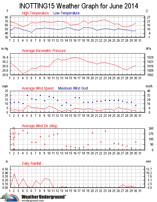
Weather Underground graph for June 2014.